我目前正在进行一些项目,并需要将下一个设计实施到Google地图中。
我在Google地图样式参考中没有找到任何回答这个问题的线索-https://developers.google.com/maps/documentation/javascript/style-reference
所以,我想知道 - 是否有可能(只使用API)?
还是需要某些黑客技巧?例如,我考虑让水域透明,并将点状图像放在地图后面。
提前致谢!
我目前正在进行一些项目,并需要将下一个设计实施到Google地图中。
我在Google地图样式参考中没有找到任何回答这个问题的线索-https://developers.google.com/maps/documentation/javascript/style-reference
所以,我想知道 - 是否有可能(只使用API)?
还是需要某些黑客技巧?例如,我考虑让水域透明,并将点状图像放在地图后面。
提前致谢!
styles: [{
              "elementType": "geometry.fill",
                  "stylers": [{
                  "visibility": "off"
              }]
          }, {
              "featureType": "landscape.natural.landcover",
                  "elementType": "geometry.fill",
                  "stylers": [{
                  "visibility": "on"
              }]
          }]
mapOptions中,您需要声明您希望首先关闭水域和陆地的可见性,其次打开陆地的可见性。请注意保留HTML标签。
function initialize() {
          var mapOptions = {
            zoom: 2,
              center: new google.maps.LatLng(43.27749, -92.658775),
              styles: [{
                  "elementType": "geometry.fill",
                      "stylers": [{
                      "visibility": "off"
                  }]
              }, {
                  "featureType": "landscape.natural.landcover",
                      "elementType": "geometry.fill",
                      "stylers": [{
                      "visibility": "on"
                  }]
              }]
          };
          map = new google.maps.Map(document.getElementById('map_canvas'),
          mapOptions);
      }

google.maps.event.addDomListener(window, 'load', initialize);<script src="https://maps.googleapis.com/maps/api/js?v=3.exp&sensor=false&.js"></script>
<div id="map_canvas" style="height:300px;"></div>mapOptions参数中实现:backgroundColor: 'none'
这给出:
var mapOptions = {
              backgroundColor: 'none',
          zoom: 2,
          center: new google.maps.LatLng(43.27749, -92.658775),
          styles: [{
              "elementType": "geometry.fill",
                  "stylers": [{
                  "visibility": "off"
              }]
          }, {
              "featureType": "landscape.natural.landcover",
                  "elementType": "geometry.fill",
                  "stylers": [{
                  "visibility": "on"
              }]
          }]
      };
      map = new google.maps.Map(document.getElementById('map_canvas'),
      mapOptions);
function initialize() {
          var mapOptions = {
            backgroundColor: 'none',
              zoom: 2,
              center: new google.maps.LatLng(43.27749, -92.658775),
              styles: [{
                  "elementType": "geometry.fill",
                      "stylers": [{
                      "visibility": "off"
                  }]
              }, {
                  "featureType": "landscape.natural.landcover",
                      "elementType": "geometry.fill",
                      "stylers": [{
                      "visibility": "on"
                  }]
              }]
          };
          map = new google.maps.Map(document.getElementById('map_canvas'),
          mapOptions);
      }

google.maps.event.addDomListener(window, 'load', initialize);<script src="https://maps.googleapis.com/maps/api/js?v=3.exp&sensor=false&.js"></script>
<div id="map_canvas" style="height:300px;"></div>最后,以下代码片段是一个非常简单的示例。地图背后有渐变颜色,地图的默认背景颜色被移除,并关闭了水的可见性。
 function initialize() {
          var mapOptions = {
            backgroundColor: 'none',
              zoom: 2,
              center: new google.maps.LatLng(43.27749, -92.658775),
              styles: [{
                  "elementType": "geometry.fill",
                      "stylers": [{
                      "visibility": "off"
                  }]
              }, {
                  "featureType": "landscape.natural.landcover",
                      "elementType": "geometry.fill",
                      "stylers": [{
                      "visibility": "on"
                  }]
              }]
          };
          map = new google.maps.Map(document.getElementById('map_canvas'),
          mapOptions);
      }

      google.maps.event.addDomListener(window, 'load', initialize);
.gradient {
height: 200px;
background: -webkit-repeating-linear-gradient(white, blue); /* For Safari 5.1 to 6.0 */
background: -o-repeating-linear-gradient(white, blue); /* For Opera 11.1 to 12.0 */
background: -moz-repeating-linear-gradient(white, blue); /* For Firefox 3.6 to 15 */
background: repeating-linear-gradient(white, blue); /* Standard syntax (must be last) */
}<script src="https://maps.googleapis.com/maps/api/js?v=3.exp&sensor=false&.js"></script>
<div id="map_canvas" class="gradient" style="height:300px;"></div>注意:如果你有一个不同于我的回答并且扩展了我的内容的答案,请随意复制我的任何部分。
据我所知,不支持使用rgba颜色。由于没有支持的颜色格式进行alpha操作,我认为很难直接获得所需的结果。
下面有两个示例。
由于某种原因,我必须多次点击“运行代码段”(5-6次)才能使其正常运行。(为什么?)
1- 使用十六进制格式的常规RGB颜色值来操作水的颜色- 可以工作但没有透明度
function initMap() {
    var map = new google.maps.Map(document.getElementById('map'), {
      center: {
        lat: 40.674,
        lng: -73.945
      },
      zoom: 12,
      styles: [{
        "featureType": "water",
        "elementType": "geometry",
        "stylers": [{
          color: '#ff99cc'
        }],
      }]
    })
  }
#map {
height: 100%;
width: 100%;
}
html,
body {
height: 100%;
margin:0 auto;
}<script src="https://maps.googleapis.com/maps/api/js?key=AIzaSyDHu4QBgWONqtdOWVLTW5XZ51B1eOU6SWw&callback=initMap" async defer></script>
<div id="map"></div>2- 关闭水体几何的可见性 - 由于所有地图对象都有一个默认的实心颜色背景,因此它不起作用。
function initMap() {
  var map = new google.maps.Map(document.getElementById('map'), {
    center: {
      lat: 40.674,
      lng: -73.945
    },
    zoom: 12,
    styles: [{
      "featureType": "water",
      "elementType": "geometry",
      "stylers": [{
        visibility: "off"
      }],
    }]
  })
}
#map {
height: 100%;
width: 100%;
}
html,
body {
height: 100%;
margin:0 auto;
}<script src="https://maps.googleapis.com/maps/api/js?key=AIzaSyDHu4QBgWONqtdOWVLTW5XZ51B1eOU6SWw&callback=initMap" async defer></script>
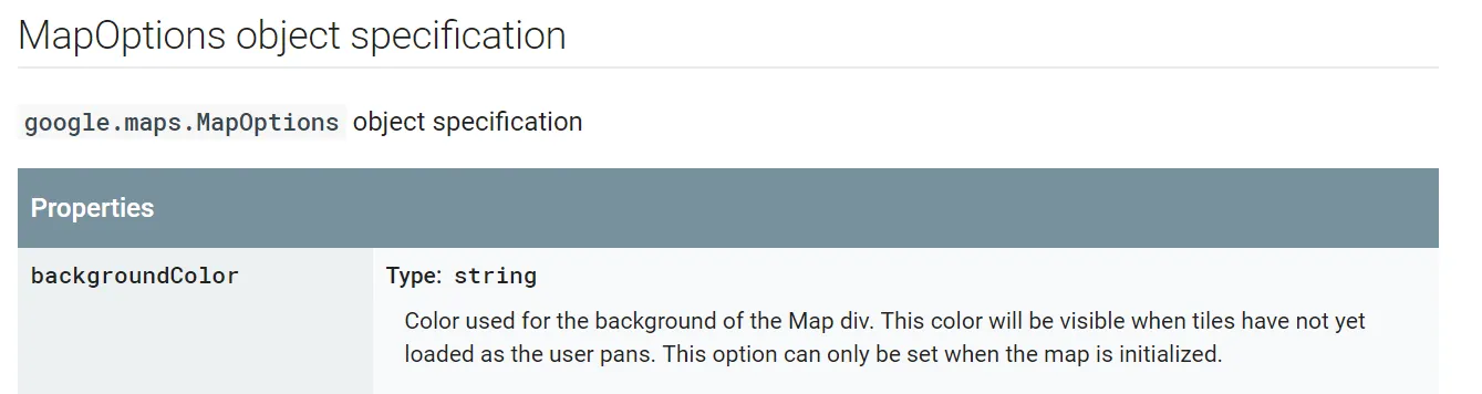
<div id="map"></div>backgroundColor,它属于google.maps.MapOptions。Google对该变量的定义如下:
 您可以在Google Maps JavaScript API V3参考文档中了解更多信息。
算了吧……
上面的变量仅控制瓷砖加载前的背景颜色。我在本教程中发现了这一点,供有兴趣的人参考。
您可以在Google Maps JavaScript API V3参考文档中了解更多信息。
算了吧……
上面的变量仅控制瓷砖加载前的背景颜色。我在本教程中发现了这一点,供有兴趣的人参考。