如何实现以下内容:
- 用户定义一个地址
- 用户定义一个颜色
- 服务在谷歌地图上查找相应的建筑
- 服务用颜色填充找到的建筑物
我知道如何:
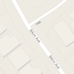
1.查找地址的纬度和经度
2.绘制多边形
因此,为了完成任务,我需要从地址获取建筑物的多边形坐标。如何做到这一点?
如何实现以下内容:
我知道如何:
1.查找地址的纬度和经度
2.绘制多边形
因此,为了完成任务,我需要从地址获取建筑物的多边形坐标。如何做到这一点?
你可以使用 Google Geocoding API 将地址转换为地理坐标。
https://maps.googleapis.com/maps/api/geocode/json?address=SOME_ADDRESS&key=YOUR_API_KEY
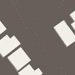
然后,您可以使用Python和一个样式化的静态地图,在某个位置获取建筑物的多边形(以像素坐标表示):
import numpy as np
from requests.utils import quote
from skimage.measure import find_contours, points_in_poly, approximate_polygon
from skimage import io
from skimage import color
from threading import Thread

center_latitude = None ##put latitude here
center_longitude = None ##put longitude here
mapZoom = str(20)
midX = 300
midY = 300
# Styled google maps url showing only the buildings
safeURL_Style = quote('feature:landscape.man_made|element:geometry.stroke|visibility:on|color:0xffffff|weight:1')
urlBuildings = "http://maps.googleapis.com/maps/api/staticmap?center=" + str_Center + "&zoom=" + mapZoom + "&format=png32&sensor=false&size=" + str_Size + "&maptype=roadmap&style=visibility:off&style=" + safeURL_Style

mainBuilding = None
imgBuildings = io.imread(urlBuildings)
gray_imgBuildings = color.rgb2gray(imgBuildings)
# will create inverted binary image
binary_imageBuildings = np.where(gray_imgBuildings > np.mean(gray_imgBuildings), 0.0, 1.0)
contoursBuildings = find_contours(binary_imageBuildings, 0.1)

for n, contourBuilding in enumerate(contoursBuildings):
    if (contourBuilding[0, 1] == contourBuilding[-1, 1]) and (contourBuilding[0, 0] == contourBuilding[-1, 0]):
        # check if it is inside any other polygon, so this will remove any additional elements
        isInside = False
        skipPoly = False
        for othersPolygon in contoursBuildings:
            isInside = points_in_poly(contourBuilding, othersPolygon)
            if all(isInside):
                skipPoly = True
                break

        if skipPoly == False:
            center_inside = points_in_poly(np.array([[midX, midY]]), contourBuilding)
            if center_inside:
        # approximate will generalize the polygon
                mainBuilding = approximate_polygon(contourBuilding, tolerance=2)

print(mainBuilding)
现在,您可以使用一些 JavaScript 和 Google Maps API 将像素坐标转换为纬度和经度:
function point2LatLng(point, map) {
        var topRight = map.getProjection().fromLatLngToPoint(map.getBounds().getNorthEast());
        var bottomLeft = map.getProjection().fromLatLngToPoint(map.getBounds().getSouthWest());
        var scale = Math.pow(2, map.getZoom());
        var worldPoint = new google.maps.Point(point.x / scale + bottomLeft.x, point.y / scale + topRight.y);
        return map.getProjection().fromPointToLatLng(worldPoint);
}

var convertedPointsMain = [];

for (var i = 0; i < pxlMainPolygons[p].length; i++) {
    var conv_point = {
        x: Math.round(pxlMainPolygons[p][i][1]),
        y: Math.round(pxlMainPolygons[p][i][0])
    };
    convertedPointsMain[i] = point2LatLng(conv_point, map);
}

console.log(convertedPointsMain);
// https://wiki.openstreetmap.org/wiki/Overpass_API/Overpass_QL
private static string GetOqlBuildingQuery(int distance, decimal latitude, decimal longitude)
{
    System.Globalization.NumberFormatInfo nfi = new System.Globalization.NumberFormatInfo()
    {
        NumberGroupSeparator = "",
        NumberDecimalSeparator = ".",
        CurrencyGroupSeparator = "",
        CurrencyDecimalSeparator = ".",
        CurrencySymbol = ""
    };

    // [out: json];
    // way(around:25, 47.360867, 8.534703)["building"];
    // out ids geom meta;

    string oqlQuery = @"[out:json];
way(around:" + distance.ToString(nfi) + ", "
+ latitude.ToString(nfi) + ", " + longitude.ToString(nfi)
+ @")[""building""];
out ids geom;"; // ohne meta - ist minimal

    return oqlQuery;
}


public static System.Collections.Generic.List<Wgs84Point> GetWgs84PolygonPoints(int distance, decimal latitude, decimal longitude)
{
    string[] overpass_services = new string[] {
        "http://overpass.osm.ch/api/interpreter",
        "http://overpass.openstreetmap.fr/api/interpreter",
        "http://overpass-api.de/api/interpreter",
        "http://overpass.osm.rambler.ru/cgi/interpreter",
        // "https://overpass.osm.vi-di.fr/api/interpreter", // offline...
    };

    // string url = "http://overpass.osm.ch/api/interpreter";
    // string url = "http://overpass-api.de/api/interpreter";
    string url = overpass_services[s_rnd.Next(0, overpass_services.Length)];


    System.Collections.Specialized.NameValueCollection reqparm = new System.Collections.Specialized.NameValueCollection();
    reqparm.Add("data", GetOqlBuildingQuery(distance, latitude, longitude));

    string resp = PostRequest(url, reqparm);
    // System.IO.File.WriteAllText(@"D:\username\Documents\visual studio 2017\Projects\TestPlotly\TestSpatial\testResponse.json", resp, System.Text.Encoding.UTF8);
    // System.Console.WriteLine(resp);
    // string resp = System.IO.File.ReadAllText(@"D:\username\Documents\visual studio 2017\Projects\TestPlotly\TestSpatial\testResponse.json", System.Text.Encoding.UTF8);

    System.Collections.Generic.List<Wgs84Point> ls = null;

    Overpass.Building.BuildingInfo ro = Overpass.Building.BuildingInfo.FromJson(resp);

    if (ro != null && ro.Elements != null && ro.Elements.Count > 0 && ro.Elements[0].Geometry != null)
    {
        ls = new System.Collections.Generic.List<Wgs84Point>();

        for (int i = 0; i < ro.Elements[0].Geometry.Count; ++i)
        {
            ls.Add(new Wgs84Point(ro.Elements[0].Geometry[i].Latitude, ro.Elements[0].Geometry[i].Longitude, i));
        } // Next i

    } // End if (ro != null && ro.Elements != null && ro.Elements.Count > 0 && ro.Elements[0].Geometry != null)


    return ls;
} // End Function GetWgs84Points
我已经花了好几个小时在这个问题上了,最接近的一次是找到一个请求URI,它返回一个带有多边形的结果。我相信它通过editids参数指定了建筑(边界)。我们只需要找到一种从建筑(边界)获取当前editids的方法。
我拥有的URI是:
https://www.google.com/mapmaker?hl=en&gw=40&output=jsonp&ll=38.934911%2C-92.329359&spn=0.016288%2C0.056477&z=14&mpnum=0&vpid=1354239392511&editids=nAlkfrzSpBMuVg-hSJ&xauth=YOUR_XAUTH_HERE&geowiki_client=mapmaker&hl=en
部分结果包含所需内容:
"polygon":[{"gnew":{"loop":[{"vertex":[{"lat_e7":389364691,"lng_e7":-923341133},{"lat_e7":389362067,"lng_e7":-923342783},{"lat_e7":389361075,"lng_e7":-923343356},{"lat_e7":389360594,"lng_e7":-923342477},