有没有一种服务或API,可以传入经度/纬度作为参数进行ping,并返回该经纬度所在的邮政编码?这仅适用于美国,因此我不必担心国际代码等问题。
我觉得Google Maps的反向地理编码对我来说太繁重了。如果可能的话,我更喜欢轻量级的东西。这将在javascript中完成。
我觉得Google Maps的反向地理编码对我来说太繁重了。如果可能的话,我更喜欢轻量级的东西。这将在javascript中完成。
它被称为反向地理编码(地址查找)。要获取纬度为40.714224,经度为-73.961452的地址,请使用参数latlng=40.714224,-73.961452&sensor=true(例子)查询http://maps.googleapis.com/maps/api/geocode/json,它会返回JSON对象或使用http://maps.googleapis.com/maps/api/geocode/xml返回XML响应(例子)。这来自于谷歌且免费。
对于Google API,根据他们的网站,您需要在Google地图中使用它:
注意:Geocoding API只能与Google地图一起使用;禁止在不显示地图的情况下使用地理编码结果。
{
  "postalCodes": [{
    "adminCode3": "1631",
    "distance": "2.2072",
    "postalCode": "8775",
    "countryCode": "CH",
    "lng": 8.998679778165283,
    "placeName": "Luchsingen",
    "lat": 46.980169648620375
  }]
}
  //Reverse GeoCode position into Address and ZipCOde
  function getZipCodeFromPosition(geocoder, map,latlng,userLocationInfoWindow) {

   geocoder.geocode({'location': latlng}, function(result, status) {
     if (status === 'OK') {
       if (result[0]) {

            console.log("GeoCode Results Found:"+JSON.stringify(result));

            //Display Address
            document.getElementById("address").textContent  = "Address: " +result[0].formatted_address;

           //Update Info Window on Server Map
           userLocationInfoWindow.setPosition(latlng);
           userLocationInfoWindow.setContent('<IMG BORDER="0" ALIGN="Left" SRC="https://media3.giphy.com/media/IkwH4WZWgdfpu/giphy.gif" style ="width:50px; height:50px"><h6 class ="pink-text">You Are Here</h4> <p class = "purple-text" style ="margin-left:30px;">'+result[0].formatted_address+'</p>');
           userLocationInfoWindow.open(map);
           map.setCenter(latlng);

            //Try to Get Postal Code
            var postal = null;
            var city = null;
            var state = null;
            var country = null;

          for(var i=0;i<result.length;++i){
              if(result[i].types[0]=="postal_code"){
                  postal = result[i].long_name;
              }
              if(result[i].types[0]=="administrative_area_level_1"){
                  state = result[i].long_name;
              }
              if(result[i].types[0]=="locality"){
                  city = result[i].long_name;
              }
              if(result[i].types[0]=="country"){
                  country = result[i].long_name;
              }
          }
          if (!postal) {
            geocoder.geocode({ 'location': result[0].geometry.location }, function (results, status) {
              if (status == google.maps.GeocoderStatus.OK) {

                //Postal Code Not found, Try to get Postal code for City
                var result=results[0].address_components;

                for(var i=0;i<result.length;++i){
                 if(result[i].types[0]=="postal_code"){
                    postal = result[i].long_name;
                 }
                }
                  if (!postal) {

                    //Postal Code Not found
                     document.getElementById("postal").textContent  = "No Postal Code Found  for this location";
                  }else
                  {
                     //Postal Code found
                      document.getElementById("postal").textContent  = "Zip Code: "+postal;
                  }
              }
          });
          } else
              {
              //Postal Code found
              document.getElementById("postal").textContent  = "Zip Code: "+postal;
              }
          console.log("STATE: " + state);
          console.log("CITY: " + city);
          console.log("COUNTRY: " + country);

             } else {
           window.alert('No results found');
         }
       } else {
         window.alert('Geocoder failed due to: ' + status);
       }
     });
 }
</script>
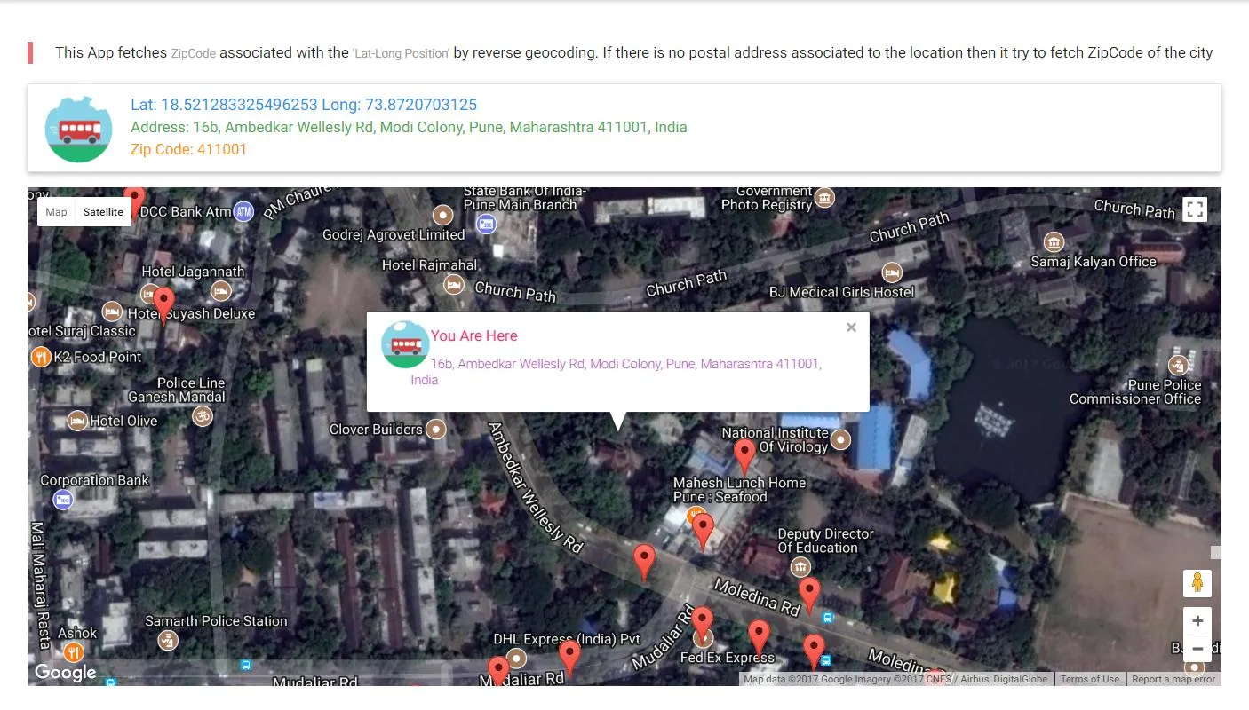
https://codepen.io/hiteshsahu/pen/gxQyQE?editors=1010
//javascript function
function getZipFromLatLong() {
    var url = "getzip.php";
    var formData = new FormData();
    formData.append("lat", current_lat);
    formData.append("long", current_long);

    var r = new XMLHttpRequest();
    r.open("POST", url, true);
    r.onreadystatechange = function () {
        if (r.readyState != 4 || r.status != 200) {
            return;
        } else {
            data = r.responseText;
            var jdata = JSON.parse(data);
            document.getElementById("zip").value = jdata.postalCodes[0].postalCode;
        }
    }
    r.send(formData);
}

//getzip.php script
<?php

$lat = $_POST["lat"];
$long = $_POST["long"];

$url = "http://api.geonames.org/findNearbyPostalCodesJSON?username=demo&lat=" . $lat .  "&lng=" . $long;

$content = file_get_contents($url);

//the output is json, so just return it as-is
die($content);
?>