我正在使用Mapbox Supercluster制作一个聚类地图。我面临的问题是聚类点的位置不正确。例如,我只有荷兰的狗,但当缩小比例时它们也在法国。请注意,保留HTML标签。
问题可以在我的网站https://v2.sayhi.dog/?dog-map=true上看到。
我的代码如下(我使用vue.js):
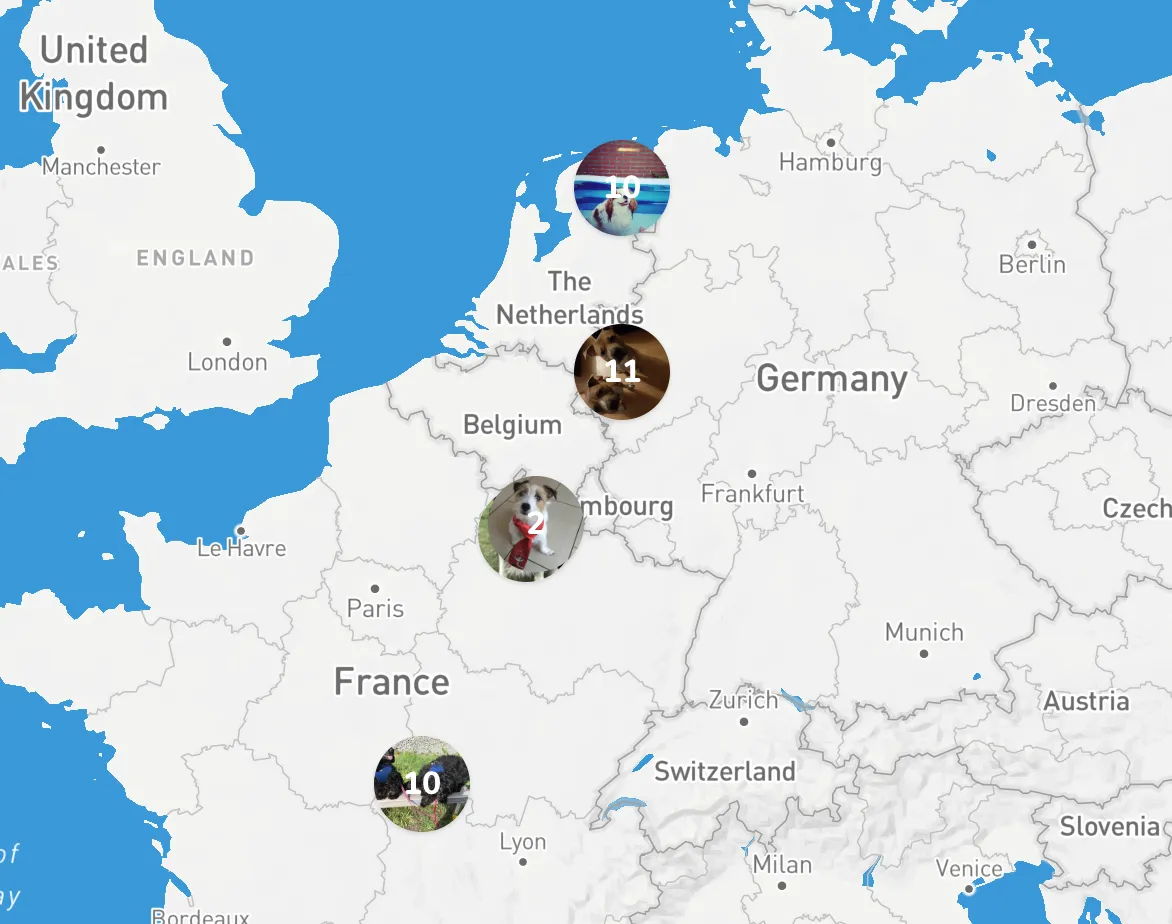
问题可以在我的网站https://v2.sayhi.dog/?dog-map=true上看到。
我的代码如下(我使用vue.js):
<template>
    <div class="w-full h-full" id="map"></div>
</template>

<script>
    import mapboxgl from 'mapbox-gl'
    import Supercluster from 'supercluster';

    export default {
        props: ['locations'],

        data() {
            return {
                map: null,
                copyLocations: this.locations,
                clusters: [],
                markers: [],
                clustersGeojson: {},
                clusterIndex: null,
            }
        },

        mounted() {
            mapboxgl.accessToken = 'my-token';
            // init the map
            this.map = new mapboxgl.Map({
                container: 'map',
                style: 'mapbox://styles/sayhi/cjkp9e59x3m3y2rm1zbcc0c',
                zoom: 2,
            });

            this.addControls();
            this.map.on("load", () => { this.addMarkers() });
            this.map.addControl(new mapboxgl.NavigationControl());
        },

        methods: {
            addMarkers() {
                this.clusterIndex = new Supercluster({
                    radius: 40,
                    maxZoom: 10
                });

                this.clusterIndex.load(this.locations.features);
                this.map.on('moveend', () => { this.moveEnd(); });
                this.updateClusters();
            },

            updateClusters() {
                var bounds = this.map.getBounds(),
                    zoom = this.map.getZoom();

                this.clustersGeojson = this.clusterIndex.getClusters([
                    bounds.getWest(),
                    bounds.getSouth(),
                    bounds.getEast(),
                    bounds.getNorth()
                ], Math.floor(zoom));

                if (Object.keys(this.clusters).length) {
                    this.clusters.forEach(function(cluster) {
                        cluster.remove();
                    });
                }

                this.displayFeatures(this.clustersGeojson);
            },

            addControls() {
                this.map.addControl(new mapboxgl.NavigationControl(), "bottom-right");
                this.map.addControl(new mapboxgl.FullscreenControl(), "bottom-right");
            },

            moveEnd() {
                this.updateClusters();
            },

            displayFeatures(features) {
                if (this.markers.length) {
                    this.markers.forEach(function(marker) {
                        marker.remove();
                    });
                }

                features.forEach((feature) => {
                    var isCluster = (!!feature.properties.cluster) ? true : false,
                        $feature;

                    if (isCluster) {
                        var leaf = this.clusterIndex.getLeaves(feature.properties.cluster_id)[0];
                        $feature = document.createElement("div");
                        $feature.className = 'flex items-center justify-center w-12 h-12 rounded-full text-center text-white font-bold shadow bg-cover cursor-pointer bg-center';
                        $feature.style.backgroundImage = `url(${leaf.properties.image})`;

                        var $inner = document.createElement("div");
                        $inner.innerHTML = feature.properties.point_count_abbreviated;

                        $feature.appendChild($inner);
                        this.clusters[feature.properties.cluster_id] = new mapboxgl.Marker($feature).setLngLat(feature.geometry.coordinates).addTo(this.map);
                    } else {
                        $feature = document.createElement('div');
                        $feature.className = 'flex items-center justify-center w-12 h-12 rounded-full text-center text-white font-bold shadow bg-cover cursor-pointer bg-center';
                        $feature.style.backgroundImage = `url(${feature.properties.image})`;

                        this.markers.push(new mapboxgl.Marker($feature).setLngLat(feature.geometry.coordinates).addTo(this.map));
                    }
                });
            }
        }
    }
</script>
https://gist.github.com/larsjanssen6/ebb5d7e3887c885af4c65d294ca1fb77
这是一个非常令人沮丧的问题,我已经苦苦挣扎了几天,真的需要帮助。
--更新--
我创建了一个JSFiddle:
希望有人能够帮助。
mapbox-gl.css文件。请参见我的答案。 - Leon