我正在构建一个应用程序,其中需要在世界地图上动态突出显示一些国家。
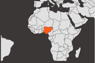
简而言之,我想要自定义iOS地图的整个视图,如图所示。是否可以使用MapKit或其他方法实现?提前感谢。
RMShape类在RMAnnotation上为地图添加/着色所需的国家多边形。这听起来有点复杂,但相关工具完全免费且开源,我可以帮助您完成此过程。
import UIKit
import CoreLocation

struct GeoJson: Codable {
    let type: String
    let features: [GeoJsonFeature]
}

struct GeoJsonFeature: Codable {
    let type: String
    let geometry: GeoJsonGeometry
}

struct GeoJsonGeometry: Codable {
    let type: String
    let coordinates: GeoJsonCoordinates
}

struct GeoJsonCoordinates: Codable {
    var point: [Double]?
    var line: [[Double]]?
    var polygon: [[[Double]]]?
    var multiPolygon: [[[[Double]]]]?

    init(from decoder: Decoder) throws {
        let container = try decoder.singleValueContainer()
        if let point = try? container.decode([Double].self) {
            self.point = point
            return
        }
        if let line = try? container.decode([[Double]].self) {
            self.line = line
            return
        }
        if let polygon = try? container.decode([[[Double]]].self) {
            self.polygon = polygon
            return
        }
        if let multiPolygon = try? container.decode([[[[Double]]]].self) {
            self.multiPolygon = multiPolygon
            return
        }
        throw DecodingError.valueNotFound(Self.self, .init(codingPath: [], debugDescription: ""))
    }
}

class ViewController: UIViewController {

    override func viewDidLoad() {
        super.viewDidLoad()
        loadGeoJson()
    }

    func loadGeoJson() {
        guard let url = Bundle.main.url(forResource: "ne_110m_admin_0_countries", withExtension: "geojson"),
              let data = try? Data(contentsOf: url),
              let geoJson = try? JSONDecoder().decode(GeoJson.self, from: data)
        else {
            return
        }

        for feature in geoJson.features {
            let geometry = feature.geometry

            let randomColor = UIColor(hue: Double.random(in: 0...1), saturation: 1, brightness: 1, alpha: 1)

            // check https://macwright.com/2015/03/23/geojson-second-bite.html for other types info if needed
            // note that below we do not support it exactly as it should (internal cutouts in polygons are ignored)
            // but for needed purpose it should not make a big difference

            if geometry.type == "Polygon", let coordinates = feature.geometry.coordinates.polygon {
                for polygon in coordinates {
                    addShape(polygon: polygon, color: randomColor)
                }
            }
            if geometry.type == "MultiPolygon", let coordinates = feature.geometry.coordinates.multiPolygon {
                for multiPolygon in coordinates {
                    for polygon in multiPolygon {
                        addShape(polygon: polygon, color: randomColor)
                    }
                }
            }
        }
    }

    func addShape(polygon: [[Double]], color: UIColor) {
        let polygonCoordinates: [CLLocationCoordinate2D] = polygon.map { coordinate in
            CLLocationCoordinate2D(latitude: coordinate[1], longitude: coordinate[0])
        }
        let points: [CGPoint] = polygonCoordinates.map { coordinate in
            coordinateToPoint(coordinate)
        }
        let path = UIBezierPath()
        path.move(to: points[0])
        for point in points {
            path.addLine(to: point)
        }
        path.close()

        let shapeLayer = CAShapeLayer()
        shapeLayer.path = path.cgPath
        shapeLayer.fillColor = color.cgColor
        shapeLayer.position = CGPoint(x: 50, y: 200)

        view.layer.addSublayer(shapeLayer)
    }

    func coordinateToPoint(_ coordinate: CLLocationCoordinate2D) -> CGPoint {
        let width = 300.0
        let height = 200.0
        let x = (coordinate.longitude + 180.0) * (width / 360.0)
        let latitudeRadians = coordinate.latitude * .pi / 180.0
        let n = log(tan((.pi / 4.0) + (latitudeRadians / 2.0)))
        let y = (height / 2.0) - (width * n / (2.0 * .pi))
        return CGPoint(x: x, y: y)
    }
}