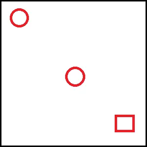
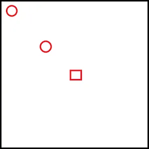
这与这个问题非常相似。我希望确保所有标记在当前缩放级别下都能显示出来。但是,我也想预先选择中心点(用户的当前位置)。如果圆圈是标记,而正方形是我预期的中心点,在下面的图片中,链接的解决方案将创建第一个(左,上)图像。我想要第二个(右,下)图像。
这与这个问题非常相似。我希望确保所有标记在当前缩放级别下都能显示出来。但是,我也想预先选择中心点(用户的当前位置)。如果圆圈是标记,而正方形是我预期的中心点,在下面的图片中,链接的解决方案将创建第一个(左,上)图像。我想要第二个(右,下)图像。
LatLngBounds 对象,并将每个标记的坐标作为其扩展。然后获取你的边界对象的东北和西南坐标,并检查这些坐标是否包含在当前地图边界内。如果没有,则缩小地图并重试。bounds.extend(position) 和 fitAllBounds 函数。
var map, bounds;

function initialize() {

  var southWest = new google.maps.LatLng(40, -70);
  var northEast = new google.maps.LatLng(35, -80);
  var lngSpan = northEast.lng() - southWest.lng();
  var latSpan = northEast.lat() - southWest.lat();

  var center = new google.maps.LatLng(40, -70);

  map = new google.maps.Map(document.getElementById("map-canvas"), {
    zoom: 12,
    center: center,
    mapTypeId: google.maps.MapTypeId.ROADMAP
  });

  // Add center marker
  new google.maps.Marker({
    position: center,
    label: 'C',
    map: map
  });

  // Create the bounds object
  bounds = new google.maps.LatLngBounds();

  // Create random markers
  for (var i = 0; i < 20; i++) {

    // Calculate a random position
    var position = new google.maps.LatLng(southWest.lat() + latSpan * Math.random(), southWest.lng() + lngSpan * Math.random());

    var marker = new google.maps.Marker({
      position: position,
      map: map
    });

    google.maps.event.addListener(marker, 'click', (function(marker, i) {
      return function() {
        map.setZoom(5);
        map.setCenter(marker.position);
      }
    })(marker, i));

    // Extend the bounds with the last marker position
    bounds.extend(position);
  }

  // Fit all bounds once, when the map is ready
  google.maps.event.addListenerOnce(map, 'idle', function() {

    fitAllBounds(bounds);
  });
}

function fitAllBounds(b) {

  // Get north east and south west markers bounds coordinates
  var ne = b.getNorthEast();
  var sw = b.getSouthWest();

    // Get the current map bounds
  var mapBounds = map.getBounds();

  // Check if map bounds contains both north east and south west points
  if (mapBounds.contains(ne) && mapBounds.contains(sw)) {

    // Everything fits
    return;

  } else {

    var mapZoom = map.getZoom();

    if (mapZoom > 0) {

      // Zoom out
      map.setZoom(mapZoom - 1);

      // Try again
      fitAllBounds(b);
    }
  }
}

initialize();
#map-canvas {
height: 200px;
width: 200px;
}<div id="map-canvas"></div>
<script src="https://maps.googleapis.com/maps/api/js?key=AIzaSyCkUOdZ5y7hMm0yrcCQoCvLwzdM6M8s5qk"></script>这里还有 JSFiddle 上的示例: