如何在地图上(ggplot)添加比例尺和指北针?

7

我正在尝试使用“ggsn”包放置比例尺和指北针。但是,我收到了一个错误消息:

错误:annotation_custom仅适用于笛卡尔坐标

此外还有警告消息:

1:在min(data $ long)中:没有非缺失参数;返回Inf

2:在max(data $ long)中:没有非缺失参数;返回-Inf

3:在min(data $ lat)中:没有非缺失参数;返回Inf

4:在max(data $ lat)中:没有非缺失参数;返回-Inf

5:删除了1374840行包含非有限值的数据(stat_contour)。

我的代码如下:

#loading the map
world <- maps::map("world2", fill=TRUE, plot=FALSE) # world2 is the Pacific centered map with longitude [0,360]

IDs <- sapply(strsplit(world$names, ":"), function(x) x[1])
world <- map2SpatialPolygons(world, IDs=IDs, proj4string=CRS("+proj=longlat +datum=WGS84 +no_defs +ellps=WGS84 +towgs84=0,0,0"))

world_map <- fortify(world)

#load the bathymetry 
bat <- marmap::getNOAA.bathy(lon1 = -5.0000, lon2 = -80.0000, lat1 = 14, lat2 = -70.61, keep=T) 

#converting the bathymetry in data.frame
bat2 = marmap::fortify.bathy(bat) 

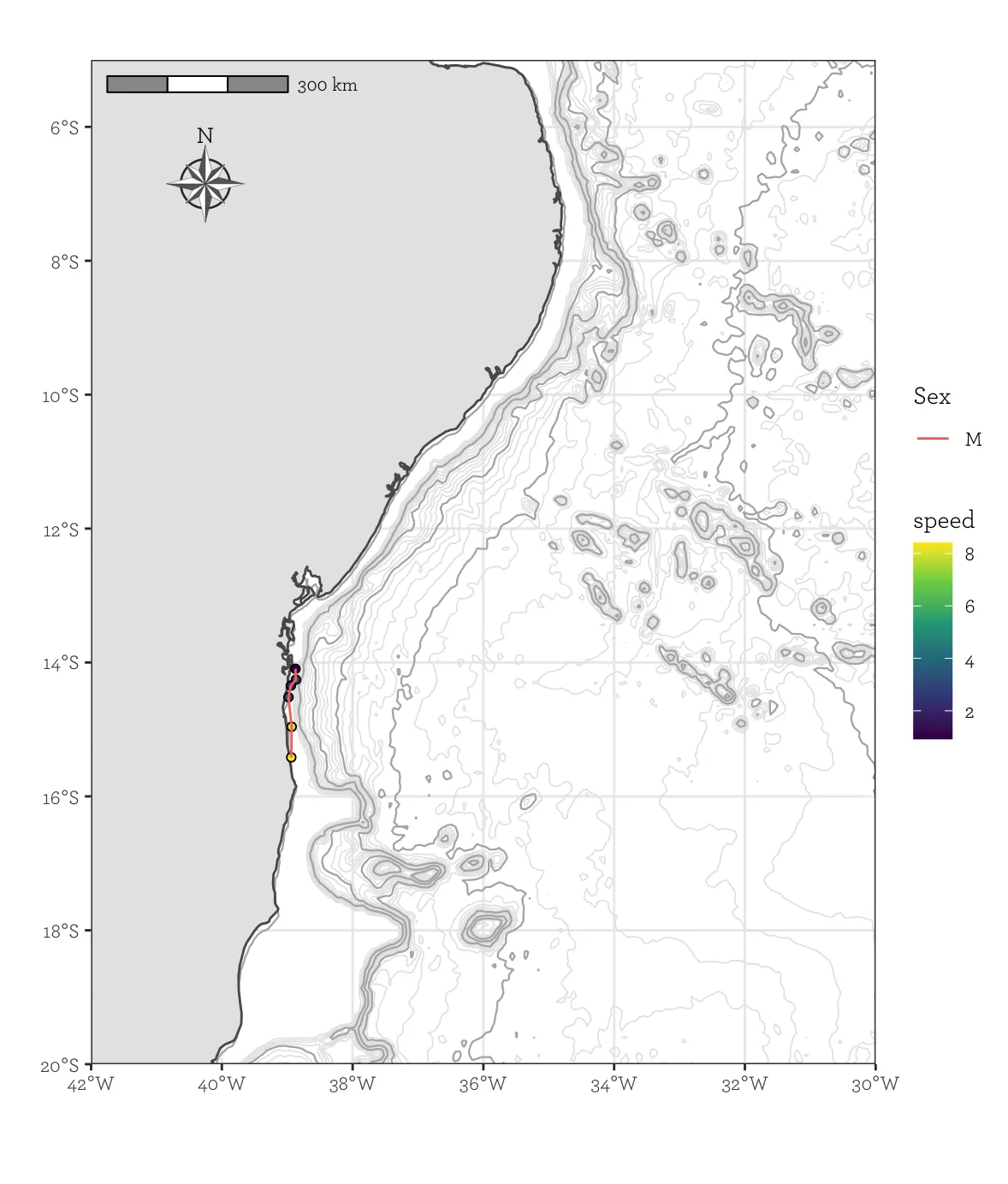
g <- ggplot(AR, aes(x = lon, y = lat)) + #(old: Longitude #Latitude)
 geom_path(aes(group = sex, col = sex), size = 0.8, alpha = 0.5) +
 geom_map(data = world_map, map=world_map, aes(x = long, y = lat, map_id = id), fill = "darkgray") +
  geom_contour(data = bat2, 
               aes(x=x, y=y, z=z),
               breaks=c(-200),
               size=c(0.3),
               colour="blue")+
  xlim(extendrange(AR$lon, f = 0.1)) + #(old: Longitude)
  ylim(extendrange(AR$lat, f = 0.1)) + #(old: Latitude)
  coord_map("ortho", orientation = c(-40, -40, 0))

g +
  ggsn::scalebar(world_map, dist = 100,location = "bottomright", transform = TRUE, #Adicione uma barra de escala
                 dist_unit = "km", st.dist = 0.03, st.size = 2, model = 'WGS84') +
  ggsn::north(world_map, scale = .1)

我的一部分数据:

structure(list(lon = c(-38.8745, -38.8676, -38.9445, -38.9811, 
-38.9322, -38.9386), lat = c(-14.09437, -14.25664, -14.34518, 
-14.51857, -14.95994, -15.41684), bmode = c(1.396, 1.375, 1.346, 
1.248, 1.074, 1.289), bmode.5 = c(1, 1, 1, 1, 1, 1), ID = structure(c(53L, 
53L, 53L, 53L, 53L, 53L), .Label = c("10946.05", "20162.03", 
"21792.03", "21800.03", "21810.03", "24640.03", "24641.05", "24642.03", 
"27258.05", "27259.03", "27261.03", "27261.05", "27261.07", "33000.05", 
"37231.07", "37234.05", "37288.07", "42521.07", "50682.07", "50687.07", 
"60004.07", "81122.09", "81123.09", "81124.09", "81125.09", "81126.09", 
"84497.1", "87632.12", "87759.08", "87761.08", "87762.08", "87763.08", 
"87764.08", "87765.08", "87766.08", "87768.08", "87768.11", "87769.11", 
"87770.08", "87773.08", "87773.1", "87773.11", "87774.09", "87774.11", 
"87775.08", "87776.08", "87776.11", "87777.1", "87778.08", "87783.09", 
"88724.1", "88727.09", "111868.11", "111871.12", "112702.12", 
"112712.12", "112714.12", "120947.12", "121189.12", "121192.12", 
"121196.12", "1211931.12"), class = "factor"), sex = structure(c(3L, 
3L, 3L, 3L, 3L, 3L), .Label = c("F", "Fc", "M"), class = "factor"), 
    speed = c(0.921691675, 2.990097297, 2.137609076, 3.259383146, 
    8.173674567, 8.413534172), area = structure(c(3L, 3L, 3L, 
    3L, 3L, 3L), .Label = c("AA", "AM", "AR"), class = "factor"), 
    angulo = c(41.027, -43.41, 29.056, 18.241, -7.125, -4.702
    ), angle_rel = c(0.7160619, -0.7576522, 0.5071251, 0.3183724, 
    -0.1243479, -0.08206201), bat.depth = c(-45L, -397L, -32L, 
    -29L, -21L, -3L), dist = c(5.53015005, 17.94058378, 12.82565446, 
    19.55629887, 49.0420474, 50.48120503), angulo_modulo = c(41.027, 
    43.41, 29.056, 18.241, 7.125, 4.702), curva = structure(c(1L, 
    1L, 1L, 1L, 1L, 1L), .Label = c("curva", "reta"), class = "factor")), row.names = 2:7, class = "data.frame")

我该如何解决这个问题?

####编辑 1

我已经编辑了我的帖子,现在对象'world_map'可用。

我在使用ggspatial时遇到了困难。 我加载了你提到的所有包并运行了命令,但无法执行函数。 我尝试添加包'ggspatial',但出现以下消息:

"* installing * source * package 'ggspatial' ...
** package 'ggspatial' successfully unpacked and MD5 sums checked
** R
** inst
** byte-compile and prepare package for lazy loading
Error: .onLoad failed in loadNamespace () for 'sf', details:
  call: get (genname, envir = envir)
  error: object 'group_split' not found
ERROR: lazy loading failed for package 'ggspatial'
* removing 'C: /Users/annel/OneDrive/Documentos/R/win-library/3.5/ggspatial'
In R CMD INSTALL
Warning in install.packages:
  installation of package ‘ggspatial’ had non-zero exit status

The downloaded source packages are in
‘C: \ Users \ annel \ AppData \ Local \ Temp \ RtmpKueyQV \ downloaded_packages’ "

当我执行您请求的命令时,我收到以下消息:
Error in loadNamespace (name): there is no package called ‘ggspatial’

@IanCampbell 我编辑了我的帖子。谢谢! - Anne Elise
2个回答

12

我不清楚ggsn包,但如果你愿意使用ggspatial包,这里是一个我理解你试图实现的示例。由于我无法复制你的代码,因此我包括了我的自定义数据集和海底地形数据...最后的地图看起来更好看,使用了一些漂亮的字体!

# Load necessary packages
library(tidyverse)
library(ggrepel)
library(sf)
library(marmap)

# Create random data
fake_data <- tibble(
  Latitude = c(45.36, 46.74, 45.35, 45.28, 45.21, 45.92, 43.83, 46.80, 43.70, 43.97),
  Year = factor(c(2010, 2010, 2010, 2010, 2010, 2007, 2008, 2008, 2008, 2008)),
  Longitude = c(-2.64, -3.33, -3.22, -2.77, -2.54, -2.69, -1.99, -2.71, -1.68, -2.16),
  Lab = c("960", "950", "956", "962", "961", "768", "865", "848", "866", "860")
)

# Transform data points into geographic objects
Sites_geo <- fake_data %>%
  st_as_sf(coords = c("Longitude", "Latitude"), crs = 4326)

# Get bathymetry data
bathy <- getNOAA.bathy(-8, 0, 42, 50, res = 1, keep = TRUE)
ggbathy <- fortify(bathy)

# Get countries outline
pays <- rnaturalearth::ne_countries(
  country = c("France", "Spain"),
  scale = "large", returnclass = "sf"
)

# Base plot
pl <- ggplot(data = pays) +
  geom_contour(
    data = ggbathy, aes(x = x, y = y, z = z),
    binwidth = 200, color = "grey80", size = 0.3
  ) +
  geom_contour(
    data = ggbathy, aes(x = x, y = y, z = z),
    binwidth = 1000, color = "grey60", size = 0.4
  ) +
  geom_sf() +
  geom_sf(data = Sites_geo, aes(fill = Year), shape = 21) +
  geom_text_repel(
    data = fake_data, aes(x = Longitude, y = Latitude, label = Lab),
    force = 3, family = "ArcherPro Book"
  ) +
  coord_sf(xlim = c(-6, 0), ylim = c(43, 48.5), expand = FALSE) +
  scale_fill_viridis_d() +
  labs(x = "", y = "", fill = "Year") +
  theme_bw(base_family = "ArcherPro Book")

# Add scale and North arrow
pl +
  ggspatial::annotation_scale(
    location = "tr",
    bar_cols = c("grey60", "white"),
    text_family = "ArcherPro Book"
  ) +
  ggspatial::annotation_north_arrow(
    location = "tr", which_north = "true",
    pad_x = unit(0.4, "in"), pad_y = unit(0.4, "in"),
    style = ggspatial::north_arrow_nautical(
      fill = c("grey40", "white"),
      line_col = "grey20",
      text_family = "ArcherPro Book"
    )
  )

在此输入图片描述


你好,感谢@Benoit的回答。我现在有另外一些问题,你能帮我解决吗?我会在我的帖子中编辑它们。 - Anne Elise
@AnneElise 如果你认为这个回答解决了你的问题,你可以考虑勾选旁边的勾号来接受它 - 谢谢! - tjebo
1
@AnneElise 看起来你尝试从源代码安装 ggspatial。 你尝试安装二进制包了吗? install.packages("ggspatial", type = "binary") - Benoit
1
@LucyWheeler 是 geom_sf() 这一行(脚本中最短的一行!)使用了ggplot(data = pays) 中在绘制国家时指定的数据。 - Benoit
非常感谢!我在使用ggsn时遇到了几个问题,但现在我的指北针和比例尺都已经用ggspatial完成了。 - HM_ft
显示剩余3条评论

5

使用存储在名为ARdata.frame中的数据,并尝试匹配所需的输出,这是我建议的:

# Load necessary packages
library(tidyverse)
library(sf)
library(marmap)

# Import AR data

# Transform data points into geographic objects
Sites_geo <- AR %>%
  st_as_sf(coords = c("lon", "lat"), crs = 4326)

# Get bathymetry data: please note I zoomed on the area of interest
# to get a more manageable dataset. If you want a larger area,
# you should increase res (e.g. res = 10) in order to get a
# bathy object of a reasonable size
bathy <- getNOAA.bathy(-45, -30, -20, -5, res = 4, keep = TRUE)
# load the bathymetry 
ggbathy <- fortify(bathy)

# Get countries outline
pays <- rnaturalearth::ne_countries(
  country = c("Brazil"),
  scale = "large", returnclass = "sf"
)

# Base plot
pl <- ggplot(data = pays) +
  geom_contour(
    data = ggbathy, aes(x = x, y = y, z = z),
    binwidth = 200, color = "grey90", size = 0.3
  ) +
  geom_contour(
    data = ggbathy, aes(x = x, y = y, z = z),
    binwidth = 1000, color = "grey70", size = 0.4
  ) +
  geom_sf() +
  geom_sf(data = Sites_geo, aes(fill = speed), shape = 21) +
  geom_path(data = AR, aes(x = lon, y = lat, group = sex, col = sex)) +
  coord_sf(xlim = c(-42, -30), ylim = c(-20, -5), expand = FALSE) +
  scale_fill_viridis_c() +
  labs(x = "", y = "", color = "Sex") +
  theme_bw(base_family = "ArcherPro Book")

# Add scale and North arrow
pl +
  ggspatial::annotation_scale(
    location = "tl",
    bar_cols = c("grey60", "white"),
    text_family = "ArcherPro Book"
  ) +
  ggspatial::annotation_north_arrow(
    location = "tl", which_north = "true",
    pad_x = unit(0.4, "in"), pad_y = unit(0.4, "in"),
    style = ggspatial::north_arrow_nautical(
      fill = c("grey40", "white"),
      line_col = "grey20",
      text_family = "ArcherPro Book"
    )
  )

这将产生以下地图:

enter image description here

比例尺和指北针的位置由ggspatial包中的annotation_scale()annotation_north_arrow()函数的locationpad_xpad_y参数控制。

这能解决你的问题吗?


网页内容由stack overflow 提供, 点击上面的
可以查看英文原文,
原文链接