var map;
var directionDisplay;
var directionsService;
var stepDisplay;
var markerArray = [];
var position;
var marker = null;
var polyline = null;
var poly2 = null;
var speed = 0.000005,
wait = 1;
var infowindow = null;
var timerHandle = null;
function createMarker(latlng, label, html) {
var contentString = '<b>' + label + '</b><br>' + html;
var marker = new google.maps.Marker({
position: latlng,
map: map,
title: label,
zIndex: Math.round(latlng.lat() * -100000) << 5
});
marker.myname = label;
google.maps.event.addListener(marker, 'click', function() {
infowindow.setContent(contentString);
infowindow.open(map, marker);
});
return marker;
}
function initialize() {
infowindow = new google.maps.InfoWindow({
size: new google.maps.Size(150, 50)
});
directionsService = new google.maps.DirectionsService();
var myOptions = {
zoom: 13,
mapTypeId: google.maps.MapTypeId.ROADMAP
};
map = new google.maps.Map(document.getElementById("map_canvas"), myOptions);
address = 'new york';
geocoder = new google.maps.Geocoder();
geocoder.geocode({
'address': address
}, function(results, status) {
map.setCenter(results[0].geometry.location);
});
var rendererOptions = {
map: map
};
directionsDisplay = new google.maps.DirectionsRenderer(rendererOptions);
stepDisplay = new google.maps.InfoWindow();
polyline = new google.maps.Polyline({
path: [],
strokeColor: '#FF0000',
strokeWeight: 3
});
poly2 = new google.maps.Polyline({
path: [],
strokeColor: '#FF0000',
strokeWeight: 3
});
}
var steps = [];
function calcRoute() {
if (timerHandle) {
clearTimeout(timerHandle);
}
if (marker) {
marker.setMap(null);
}
polyline.setMap(null);
poly2.setMap(null);
directionsDisplay.setMap(null);
polyline = new google.maps.Polyline({
path: [],
strokeColor: '#FF0000',
strokeWeight: 3
});
poly2 = new google.maps.Polyline({
path: [],
strokeColor: '#FF0000',
strokeWeight: 3
});
var rendererOptions = {
map: map
};
directionsDisplay = new google.maps.DirectionsRenderer(rendererOptions);
var start = document.getElementById("start").value;
var end = document.getElementById("end").value;
var travelMode = google.maps.DirectionsTravelMode.DRIVING;
var request = {
origin: start,
destination: end,
travelMode: travelMode
};
directionsService.route(request, function(response, status) {
if (status == google.maps.DirectionsStatus.OK) {
directionsDisplay.setDirections(response);
var bounds = new google.maps.LatLngBounds();
var route = response.routes[0];
startLocation = new Object();
endLocation = new Object();
var path = response.routes[0].overview_path;
var legs = response.routes[0].legs;
for (i = 0; i < legs.length; i++) {
if (i === 0) {
startLocation.latlng = legs[i].start_location;
startLocation.address = legs[i].start_address;
}
endLocation.latlng = legs[i].end_location;
endLocation.address = legs[i].end_address;
var steps = legs[i].steps;
for (j = 0; j < steps.length; j++) {
var nextSegment = steps[j].path;
for (k = 0; k < nextSegment.length; k++) {
polyline.getPath().push(nextSegment[k]);
bounds.extend(nextSegment[k]);
}
}
}
polyline.setMap(map);
map.fitBounds(bounds);
map.setZoom(18);
startAnimation();
}
});
}
var step = 50;
var tick = 100;
var eol;
var k = 0;
var stepnum = 0;
var speed = "";
var lastVertex = 1;
function updatePoly(d) {
if (poly2.getPath().getLength() > 20) {
poly2 = new google.maps.Polyline([polyline.getPath().getAt(lastVertex - 1)]);
}
if (polyline.GetIndexAtDistance(d) < lastVertex + 2) {
if (poly2.getPath().getLength() > 1) {
poly2.getPath().removeAt(poly2.getPath().getLength() - 1);
}
poly2.getPath().insertAt(poly2.getPath().getLength(), polyline.GetPointAtDistance(d));
} else {
poly2.getPath().insertAt(poly2.getPath().getLength(), endLocation.latlng);
}
}
function animate(d) {
if (d > eol) {
map.panTo(endLocation.latlng);
marker.setPosition(endLocation.latlng);
return;
}
var p = polyline.GetPointAtDistance(d);
map.panTo(p);
var lastPosn = marker.getPosition();
marker.setPosition(p);
var heading = google.maps.geometry.spherical.computeHeading(lastPosn, p);
icon.rotation = heading;
marker.setIcon(icon);
updatePoly(d);
timerHandle = setTimeout("animate(" + (d + step) + ")", tick);
}
function startAnimation() {
eol = polyline.Distance();
map.setCenter(polyline.getPath().getAt(0));
marker = new google.maps.Marker({
position: polyline.getPath().getAt(0),
map: map,
icon: icon
});
poly2 = new google.maps.Polyline({
path: [polyline.getPath().getAt(0)],
strokeColor: "#0000FF",
strokeWeight: 10
});
setTimeout("animate(50)", 2000);
}
google.maps.event.addDomListener(window, 'load', initialize);
var car = "M17.402,0H5.643C2.526,0,0,3.467,0,6.584v34.804c0,3.116,2.526,5.644,5.643,5.644h11.759c3.116,0,5.644-2.527,5.644-5.644 V6.584C23.044,3.467,20.518,0,17.402,0z M22.057,14.188v11.665l-2.729,0.351v-4.806L22.057,14.188z M20.625,10.773 c-1.016,3.9-2.219,8.51-2.219,8.51H4.638l-2.222-8.51C2.417,10.773,11.3,7.755,20.625,10.773z M3.748,21.713v4.492l-2.73-0.349 V14.502L3.748,21.713z M1.018,37.938V27.579l2.73,0.343v8.196L1.018,37.938z M2.575,40.882l2.218-3.336h13.771l2.219,3.336H2.575z M19.328,35.805v-7.872l2.729-0.355v10.048L19.328,35.805z";
var icon = {
path: car,
scale: .7,
strokeColor: 'white',
strokeWeight: .10,
fillOpacity: 1,
fillColor: '#404040',
offset: '5%',
anchor: new google.maps.Point(10, 25)
};
google.maps.LatLng.prototype.distanceFrom = function(newLatLng) {
var EarthRadiusMeters = 6378137.0;
var lat1 = this.lat();
var lon1 = this.lng();
var lat2 = newLatLng.lat();
var lon2 = newLatLng.lng();
var dLat = (lat2 - lat1) * Math.PI / 180;
var dLon = (lon2 - lon1) * Math.PI / 180;
var a = Math.sin(dLat / 2) * Math.sin(dLat / 2) + Math.cos(lat1 * Math.PI / 180) * Math.cos(lat2 * Math.PI / 180) * Math.sin(dLon / 2) * Math.sin(dLon / 2);
var c = 2 * Math.atan2(Math.sqrt(a), Math.sqrt(1 - a));
var d = EarthRadiusMeters * c;
return d;
}
google.maps.LatLng.prototype.latRadians = function() {
return this.lat() * Math.PI / 180;
}
google.maps.LatLng.prototype.lngRadians = function() {
return this.lng() * Math.PI / 180;
}
google.maps.Polygon.prototype.Distance = function() {
var dist = 0;
for (var i = 1; i < this.getPath().getLength(); i++) {
dist += this.getPath().getAt(i).distanceFrom(this.getPath().getAt(i - 1));
}
return dist;
}
google.maps.Polygon.prototype.GetPointAtDistance = function(metres) {
if (metres == 0) return this.getPath().getAt(0);
if (metres < 0) return null;
if (this.getPath().getLength() < 2) return null;
var dist = 0;
var olddist = 0;
for (var i = 1;
(i < this.getPath().getLength() && dist < metres); i++) {
olddist = dist;
dist += this.getPath().getAt(i).distanceFrom(this.getPath().getAt(i - 1));
}
if (dist < metres) {
return null;
}
var p1 = this.getPath().getAt(i - 2);
var p2 = this.getPath().getAt(i - 1);
var m = (metres - olddist) / (dist - olddist);
return new google.maps.LatLng(p1.lat() + (p2.lat() - p1.lat()) * m, p1.lng() + (p2.lng() - p1.lng()) * m);
}
google.maps.Polygon.prototype.GetPointsAtDistance = function(metres) {
var next = metres;
var points = [];
if (metres <= 0) return points;
var dist = 0;
var olddist = 0;
for (var i = 1;
(i < this.getPath().getLength()); i++) {
olddist = dist;
dist += this.getPath().getAt(i).distanceFrom(this.getPath().getAt(i - 1));
while (dist > next) {
var p1 = this.getPath().getAt(i - 1);
var p2 = this.getPath().getAt(i);
var m = (next - olddist) / (dist - olddist);
points.push(new google.maps.LatLng(p1.lat() + (p2.lat() - p1.lat()) * m, p1.lng() + (p2.lng() - p1.lng()) * m));
next += metres;
}
}
return points;
}
google.maps.Polygon.prototype.GetIndexAtDistance = function(metres) {
if (metres == 0) return this.getPath().getAt(0);
if (metres < 0) return null;
var dist = 0;
var olddist = 0;
for (var i = 1;
(i < this.getPath().getLength() && dist < metres); i++) {
olddist = dist;
dist += this.getPath().getAt(i).distanceFrom(this.getPath().getAt(i - 1));
}
if (dist < metres) {
return null;
}
return i;
}
google.maps.Polyline.prototype.Distance = google.maps.Polygon.prototype.Distance;
google.maps.Polyline.prototype.GetPointAtDistance = google.maps.Polygon.prototype.GetPointAtDistance;
google.maps.Polyline.prototype.GetPointsAtDistance = google.maps.Polygon.prototype.GetPointsAtDistance;
google.maps.Polyline.prototype.GetIndexAtDistance = google.maps.Polygon.prototype.GetIndexAtDistance;
html {
  height: 100%;
}
body {
  height: 100%;
  margin: 0px;
  font-family: Helvetica, Arial;
}
<script src="https://maps.googleapis.com/maps/api/js?libraries=geometry&key=AIzaSyCkUOdZ5y7hMm0yrcCQoCvLwzdM6M8s5qk"></script>
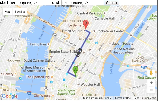
<div id="tools">start:
<input type="text" name="start" id="start" value="union square, NY" />end:
<input type="text" name="end" id="end" value="times square, NY" />
<input type="submit" onclick="calcRoute();" />
</div>
<div id="map_canvas" style="width:100%;height:90%;"></div>