我想在谷歌地图上画路径。
基本上,我正在跟踪用户位置,在特定时间间隔后。 当用户到达某个目的地时,我需要绘制他到达目的地所经过的路径。
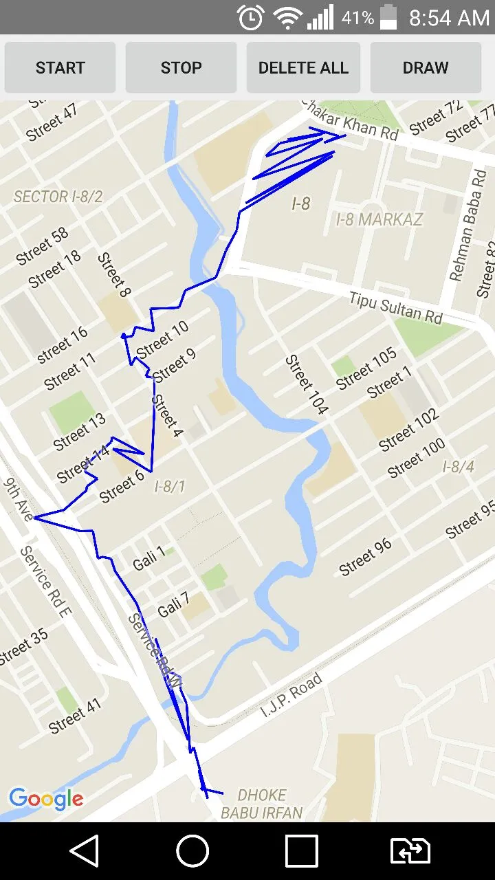
这个功能工作得很好,但问题是它显示了错乱的路径。 请参见下面的图像。
我想要什么:
我想要绘制出沿途经过的正确路径。
我尝试过的方法
我搜索并找到了这个链接,我们可以通过该链接传递最多8个点来获取方向。 这是非商业用户使用谷歌地图的最大限制。 是否有其他方法可以实现这一点。 因为我有很多要在地图上绘制的点。
用于绘制折线的代码
private void drawPath() {
        if (mMap != null)
            mMap.clear();
        int count = 0;
        LatLng prev = null;
        String[] mProjection = {LocTable.COLUMN_ID, LocTable.COLUMN_LONGITUDE, LocTable.COLUMN_LATITUDE};
        String mSelectionClause = LocTable.COLUMN_ID + "> ?";
        String[] mSelectionArgs = {"0"};
        String mSortOrder = LocTable.COLUMN_ID;

        Cursor mCursor = getContentResolver().query(
                LocContentProvider.CONTENT_URI,   // The content URI of the words table
                mProjection,                        // The columns to return for each row
                mSelectionClause,                    // Selection criteria
                mSelectionArgs,                     // Selection criteria
                mSortOrder);


        if(mCursor != null && mCursor.getCount()!=0) {

            Log.i("cursor", "Count: " + mCursor.getCount() + "|Column count: " + mCursor.getColumnCount());
            if (mCursor.moveToFirst()) {
                do {
                    if (mMap != null) {

                        float lon = mCursor.getFloat(1);
                        float lat = mCursor.getFloat(2);
                        LatLng current = new LatLng(lat, lon);

                        markerPoints.add(current);
                        if (count == 0){
                            prev = current;
                        }
                        CameraUpdate cameraUpdate = CameraUpdateFactory.newLatLngZoom(current, 19);
                        mMap.animateCamera(cameraUpdate);
                        mMap.addPolyline((new PolylineOptions())
                                .add(prev, current).width(6).color(Color.BLUE)
                                .visible(true));
                        prev=current;
                        count++;
                    }
                } while (mCursor.moveToNext());
            }

            mCursor.close();
        }
    }