我希望使用我在ArcGIS中制作的多边形矢量文件来裁剪一个栅格堆栈,然而我收到了“范围不重叠”的错误提示。
首先,我创建了栅格堆栈:
test1 < stack("C:/mydir/test1.tif")
定义投影
myCRS <- test1@crs
然后阅读shapefile。
myExtent <- readShapePoly("C:/mydir/loc1.shp", verbose=TRUE, proj4string=myCRS)
裁剪
myCrop <- crop(test1, myExtent)
Error in .local(x, y, ...) : extents do not overlap
我已经寻找解决方案,但我只发现投影可能是问题,然而它们肯定都在相同的CRS中:
> test1$test1.1
class : RasterLayer
band : 1 (of 4 bands)
dimensions : 10980, 10980, 120560400 (nrow, ncol, ncell)
resolution : 10, 10 (x, y)
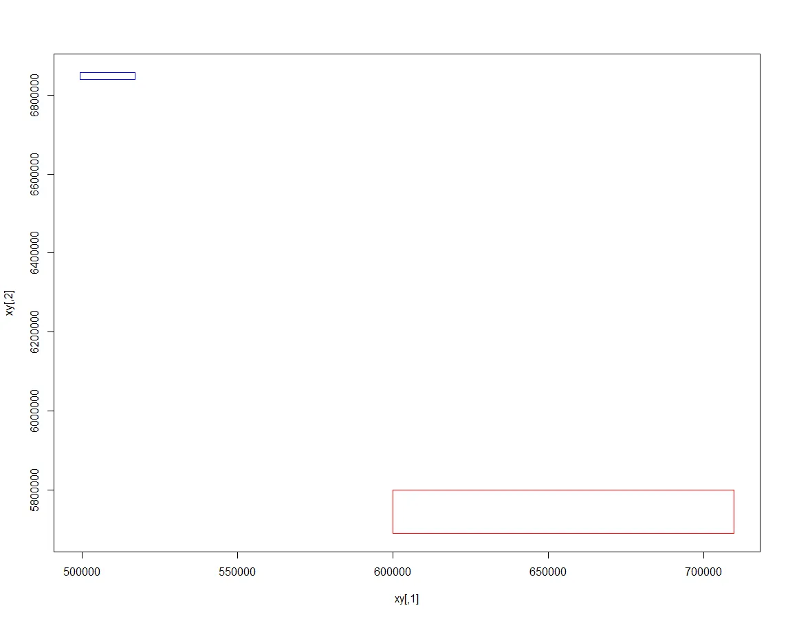
extent : 6e+05, 709800, 5690220, 5800020 (xmin, xmax, ymin, ymax)
coord. ref. : +proj=utm +zone=31 +datum=WGS84 +units=m +no_defs +ellps=WGS84
+towgs84=0,0,0
data source : C:\mydir\test1.tif
names : test1.1
values : 0, 65535 (min, max)
> myExtent
class : SpatialPolygonsDataFrame
features : 1
extent : 499386.6, 517068.2, 6840730, 6857271 (xmin, xmax, ymin, ymax)
coord. ref. : +proj=utm +zone=31 +datum=WGS84 +units=m +no_defs +ellps=WGS84
+towgs84=0,0,0
variables : 2
names : Shape_Leng, Shape_Area
min values : 67444.6461177, 283926851.657
max values : 67444.6461177, 283926851.657
myExtent <- readShapePoly("C:/mydir/loc1.shp", verbose=TRUE, proj4string=myCRS)中,你给它一个不是真实投影的投影。声明投影和转换投影之间有很大的区别。当你使用投影时,让函数从文件中读取投影,然后总是使用适当的函数(spTransform,projectRaster或gdalwarp)进行转换。 - Bastien